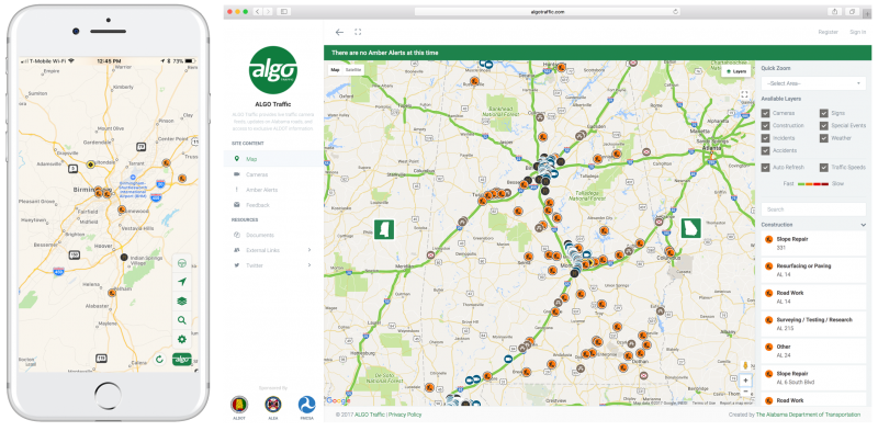
Algo Traffic was developed by CAPS under the joint sponsorship of Alabama Department of Transportation (ALDOT) and Alabama Law Enforcement Agency (ALEA) through funding from the Federal Motor Carrier Safety Administration (FMCSA). Algo Traffic provides updates on Alabama road and exclusive ALDOT information to its users, including live traffic camera feeds, message sign readouts, incident and construction information, and current road congestion levels.
Users have the ability to create a profile and sign up for push notifications, email alerts, and live camera feeds for their daily commute. Algo Traffic keeps users informed about active alerts for the state, and lets users select “driving mode” to be notified of upcoming events on their route.
Algo Traffic currently supports Birmingham, Mobile, Montgomery, Tuscaloosa, and Huntsville, with more locations coming in future phases.
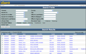
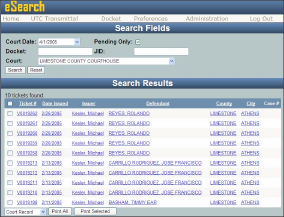
eSearch is an administrative website that has been developed to be used in conjunction with eCite. Court clerks and magistrates are given access to the site to view tickets, print tickets, mark the status of tickets, view the case associated with that ticket, and search by court date among other things. There are various search fields that enable court personnel and to ascertain a tremendous amount and array of information instantaneously.
eSwear is a virtual swearing process that allows the officer to swear to the authenticity of the ticket and the clerk to confirm via a touch-screen kiosk. We believe Alabama is the first state to implement such a system. eSearch is used in conjunction with eSwear but eSearch can also be used for courts that do not have the eSwear system.
These programs were developed in cooperation with the Alabama Administrative Office of Courts.
The Law Enforcement Tactical System (LETS) is a secure web-based search engine that has been designed to provide law enforcement and criminal justice agencies information about individuals and vehicles by searching various databases. LETS is an integration mechanism for vehicle, driver, and violation data and even produces photos to aid in positive identification of apprehended or wanted individuals. It was released in mid-January of 2003 and it rapidly became a major tool. It currently has over 1,000 agencies and over 14,000 users and its success stories are numerous.
LETS is available to all law enforcement agencies over the Internet and to officers in the field through mobile devices used in patrol cars. LETSGo is a mobile version of LETS that is optimized for usage over air cards in the patrol cars. This version has commercial vehicle information and has a built-in text to speech engine that produces voice readout of the critical summary information. LETSGo is now under the domain of the Alabama Criminal Justice Information Center who directs CAPS on LETSGo development and enhancements
Features
Built-in text to speech engine that produces voice readout of the critical summary information
Mobile Officer Virtual Environment (MOVE) was developed for officers to use on laptops in their cars, not on a desktop in the office. It was designed to combine the officer’s critical software tools onto one screen and for them to work together seamlessly.
MOVE is a software framework that integrates several software applications and peripherals, including:
ASPEN: software for federal electronic reporting of commercial vehicle violations
NCIC checks have been built into MOVE with FBI Compliant Two Factor authentication. A new set of reporting forms have been added to the MOVE suite.
GPS has been integrated so officers can capture their location and input it directly into the citation or crash form.
MapClick is the newest integration into MOVE. It is a CAPS developed mapping application that can replace MapPoint. (MapPoint is still an integrated option within MOVE.)
The LogBook feature has been redesigned for increased importation of daily officer activities from the associated applications within MOVE.
Data captured with the scanner in addition to data gathered from citations or vehicle information can easily be transferred between all the MOVE applications.
The data integration model used for MOVE is bus-based integration rather than typical peer-to-peer integration. The advantage of this is that it provides a single point of interface for all peripherals such as scanners and GPS devices. There is no need to manually intervene with each application and the peripherals. You only need to communicate with the “bus” rather than each individual application along the bus framework.
MOVE was developed in cooperation with and/or sponsored by Alabama Department of Public Safety, Alabama Administrative Office of Courts, Alabama Criminal Justice Information Center and the Federal Motor Carrier Safety Administration. The deployment of MOVE has been advanced by sponsorship from the Alabama Office of Highway Safety in the Law Enforcement and Traffic Safety Division of the Alabama Department of Economic and Community Affairs.
Currently, CAPS has projects for MOVE with the eCite component underway in three other states.
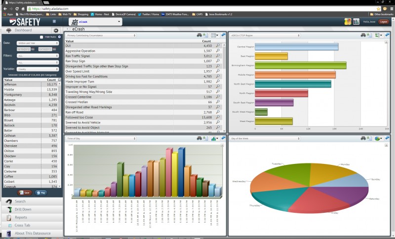
SAFETY is a powerful web portal dashboard that allows users to analyze and visualize electronic data in a variety of ways.
This dashboard is designed specifically for traffic safety professionals. It contains crash data including location information and is individually password protected for use by official traffic safety personnel.
eCrash is an electronic traffic crash reporting and transmission procedure system.
The eCrash system, like eCite, is a process-level solution to the outdated and time-consuming paper crash report form used by law enforcement and the court system. Crash reports generated through eCrash are quick, accurate, secure, and legible.
eCrash is more than a form. The development of eCrash began as a workflow solution for Alabama law enforcement’s processing of over 130,000 traffic crash reports annually. It was solidified after the state’s decision to require MMUCC compliant reports. CAPS, therefore, developed the eCrash system as a means of collecting, cleaning, and analyzing data and making that data easily accessible by all involved agencies
eCrash enables law enforcement to prepare MMUCC-5 compliant crash forms 100% electronically.
eCrash is utilized by officers in the field to document traffic crash reports and transmit the data to a server repository. Officers use the same equipment (scanner combined with a laptop, notebook or tablet PC) and software environment (MOVE) for both eCrash and eCite.
A full suite of administrative tools is available through MOVE to support the needed backend processing of crash forms and the approval and archiving of the crash data.
Overview Video
Coming Soon
Features & MOVE Integration
Driver’s license scanning (reads all 50 states)
Auto-Population of DL and GPS information
Integrates with crash diagramming applications, such as Easy Street Draw and ScenePD
Crash Report Validation to minimize errors + MMUCC 5 compliant
Eliminates redundant data entry
Improved timeliness of data
Electronic submission allows for paperless system + Web portal for supervisor approval of crash report + Web portal for analysis
Windows 7 or later compatible
Access to searchable LETS data
Find the current officer’s GPS location
Transfer the record and submit it for supervisory approval
Correct any faults in the record found by supervisors
Print the record at the roadside
Includes crash location functionality and crash diagram support
Design & Technology
eCrash transformed a major hurdle of crash data reporting by enabling the entry of crash data as close to the crash scene as possible. The eCrash system provides full-scale consistency and fewer interpretation errors in crash data.
An effortless and uncomplicated design was important to project partner, Alabama Department of Public Safety, and resulted in the following design features:
Individual reports customized to reflect any number of involved drivers, units, persons, pedestrians, or other non-motorists
Required report sections remain highlighted in red until complete
Data elements are tracked and a validation check prevents the report from being submitted with incomplete data
Electronic submission reduces duplicate efforts and provide immediate access to report data
The eCrash system was developed concurrently with Alabama’s initiative to change to MMUCC-compatible crash reports. MUCC, a voluntary data collection guideline, was developed in 1998 by the National Highway Traffic Safety Administration (NHTSA) and the Governors Highway Safety Association (GHSA) to encourage greater uniformity. The MMUCC guideline identifies a minimum set of motor vehicle crash data elements and their attributes that States should consider collecting and including in their State crash data system. The current version of eCrash is compatible with MMUCC-5, the most current version of the guideline.
History, Sponsors, & Partners
eCrash’s initial development in Alabama was sponsored by the Alabama Department of Economic and Community Affairs and directed by the Alabama Department of Public Safety. These entities continue to support eCrash through sponsorship and cooperation respectively.
A project goal was for all Alabama agencies to report all motor vehicle crashes paperlessly via the eCrash system by January 1, 2010.
2002: eCite software development began
2003: Alabama eCite rollout to state troopers
2009: eCrash deployed to all Alabama State Troopers and many police departments
2010: 100% eCrash adoption by Alabama state troopers
Arkansas adoption
2019: eCrash adoption by Mississippi
Customization for Jurisdictions
Alabama
The eCrash system was developed concurrently with Alabama’s initiative to change to MMUCC-compatible crash reports. MMUCC compliance ensures that all states have a minimal set of data elements.
Alabama Uniform Traffic Crash Report (AUTCR), a crash report system, was deployed in 2009 and is supported by the eCrash system.
Arkansas
Coming Soon
Mississippi
Coming Soon
I Want eCrash
Inquiries
eCite can be adapted for any state or municipality. If you are interested in implementing eCite, another CAPS product, or working with CAPS on a custom solution, we want to hear from you!
The Critical Analysis Reporting Environment (CARE) is a data analysis software package originally designed for problem identification and countermeasure development in traffic safety applications.
It uses advanced analytical and statistical techniques to generate valuable information directly form data.
Using CARE’s step-by-step on screen menus, it is easy to turn data into enlightening information.
CARE provides:
descriptive statistics
information mining
geographical information system access
roadway engineering support
dashboard support
CARE’s dashboard support includes access to real-time statistics on key law enforcement systems including:
traffic citations
crash reports
criminal incident reports
other critical systems for which we have developed field data capture software
Dashboards have been deployed for:
police agencies
traffic engineers
traffic safety stakeholders
While its primary use is for traffic safety, CARE can be used to process any database including:
emergency medical services
medical data
nursing data
questionnaires
criminal justice
The CARE software for traffic safety applications is available free of charge. In order to take full advantage of CARE, existing data must be converted into a CARE dataset. In the case of a state, initial state CARE data sets can be created by having the state’s current database read by CARE’s Extract=Translate-Load (ETL) to produce the various CARE datasets that form the CARE warehouse. CAPS can create the initial state CARE dataset for your state for a reasonable fee. Contact Us.
The CARE software exists in both a desktop version for Windows OS and a Web version. CARE can be downloaded here or installed from a CD. Additionally, some highway safety CARE capabilities are also available online at the CARE Online Analysis site.
CARE is an award-winning program:
NHTSA 1995 Administrator’s Public Service Award
Runner-up for the 20015 ATSIP Best Practice Award.
Using the CARE program will undoubtedly assist the traffic safety program of any organization that chooses to use it.
CARE Overview Video
Features
Statistical Generation: CARE retrieves summary information for the entire database or for any part (or subset) of it. Its Filters Menu allows the creation or combination of filters that restrict consideration to any specific subset of the database (e.g., alcohol, pedestrian, bicycle, motorcycle, particular counties or other geographical areas). Any attribute, or any combination of attributes, can be used to create filters, enabling the easy generation of literally any statistic.
Data Analysis: Charts and graphical displays are produced for any or all variables in the database. A frequency output of any variable or a cross-tabulation of any two variables is instantly displayed. (Note that the words variables and attributes are used interchangeably – for crash records, these are essentially the data elements collected on the crash report form.)
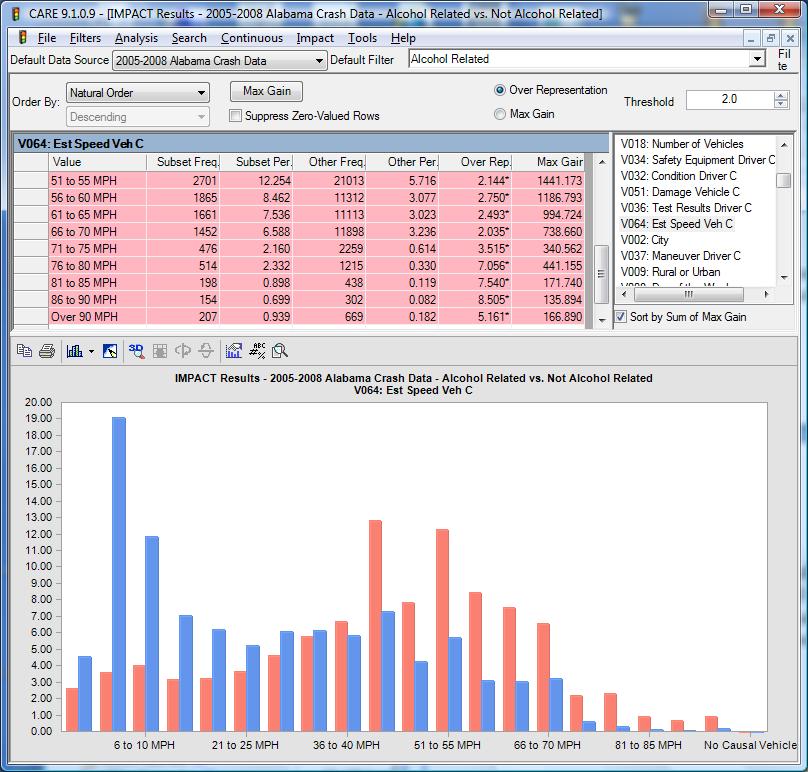
Information Mining Capability: One of the most useful capabilities of CARE lies in its unique information mining capability, called IMPACT. IMPACT automatically generates information from the data without users having to specify queries or, for that matter, even know what the attributes are in their databases. All the user has to do is to specify one or two filters. IMPACT can compare two subsets of data using a single filter, e.g., alcohol crashes vs. non-alcohol crashes. An example of this is given below for the impact speed attribute. In this example, the red bars in the chart are for the alcohol crash subset. The blue bars in the chart are for non-alcohol crashes. It is quite clear that the alcohol crashes have significantly and dramatically higher impact speeds, which clearly accounts for their higher severities. Users do not have to specify the attributes to be processed by IMPACT. Any or all can be processed simultaneously, and the results can be ordered according to the most significant first. Statistical tests are performed for all IMPACT results. Clearly, IMPACT provides the the ability to obtain crucial information from the database without having to generate endless queries. Latent information is mined out of the database, analyzed, and instantly presented in both graphical and tabular charts. The results are prioritized indicating areas where countermeasures will provide maximum gain. The information discovery potential is unlimited, offering decision-makers unprecedented information-generation power from their data warehouses.
Non-Categorical Variables: CARE is not limited to what are called “categorical” variables, i.e., those with discrete values, such as time of day, day of the week, contributing circumstances. Some applications require continuous variables, such as temperatures, distances or other such measurements. Non-categorical variables can be specified to the CARE ETL when creating a CARE dataset, allowing a list of values directly from the available raw data as opposed to being restricted to a known list of discrete values or ranges.
Narrative Data Searching: CARE can process narrative descriptions, such as that within traffic crash narratives. The goal is to generate filters to identify those records where particular words of word combinations occur. This can be quite useful since sometimes the narrative contains information that is not in the categorical variables. For example, a categorical variable may contain the fact that a deer was struck. However, it is rare that any categorical variable will contain the fact that a driver was taking evasive action to avoid a deer. This information is contained strictly in the narrative. CARE enables a word or phrase to be used to create the filter from the narrative. This filter can be combined (ORed) with all other related filters to produce the subset desired. In order to assure that the words or phrases are being used appropriately, users can view the context and either approve or disapprove the particular record. At that point, the “Generate Filter” button creates a filter that includes all of the records selected.
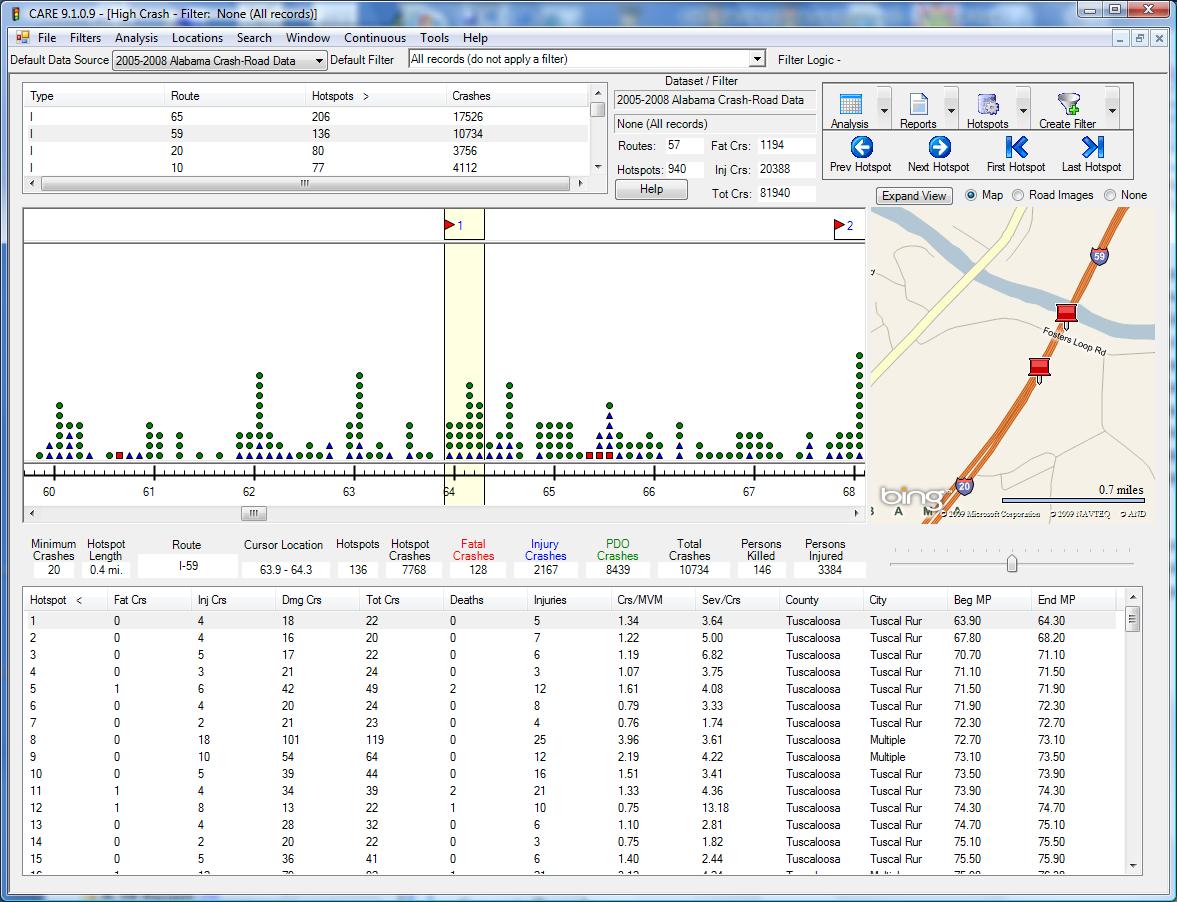
Hotspot Determination: A hotspot is a location that has a particularly high crash history, sometimes of a particular type of crash (e.g., hotspots for selective enforcement might be defined as those with excessive crashes caused by speed or alcohol). CARE uses a variety of techniques for identifying hotspots. As an example, for mileposted routes, one method is for users to specify a length of the segment and the number of crashes within the segment for it to qualify. For example, in the display given below, the criteria specified was a minimum of 20 crashes in 0.4 miles (note that this is over a four-year period). A map is given along with the strip map to assist engineers in locating the hotspots.
Report Generation: There are many options for producing various helpful reports with just the click of the mouse. Of course, the major reason for identifying hotspots is so that some countermeasure can be applied. Note the “Reports” icon in the upper right corner of the display above. This button leads to a very large number of reports that officers or engineers can take to the location in order to run down just exactly what the problems are. These reports range from overall summaries to detailed information on a per-crash basis. Any of the outputs discussed above can be exported to Microsoft Office products, including Word and Excel, enabling them to be formatted for reports or processed further.
Collision Diagram Generation: Intersection Magic is a powerful collision diagram generator that has been integrated into CARE to automatically draw collision diagrams for any location specified by CARE. This avoids the issues of having to understand all of the database ramifications of collision diagram generation, since once the location is defined within CARE the collision diagram is generated at the click of the mouse. A separate license must be obtained from Pd’ Programming in order to use this feature; Alabama has obtained a statewide license for the use of Intersection Magic.
GIS Integration: Quite analogous to the collision diagram integration, ESRI/ArcGIS has been integrated into CARE enabling analysis results from CARE to be mapped using ArcView with the click of the mouse. In addition, the GIS map can be used to create a filter so that a subset of the mapped crashes can be further analyzed in CARE. For more information on this aspect of CARE’s capabilities, see Crash Mapping Flyer.
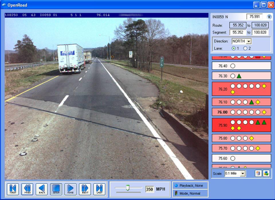
Open Road: This application links roadway images to route-event data which is generated by the standard CARE software. Users can select a location on a mileposted route and view images along that route just as if they were driving down the road, as shown below.
Along with the roadway images, OpenRoad also displays “events” that occur along the route. An event is defined as any object or occurrence that can be located with a specific route and milepost. Events are represented symbolically by a shape and color. Different types of events can be visually displayed with different symbols. For example, in the example above, fatal crashes are shown as red squares, while serious injury crashes are green triangles, and property damage only crashes are given by circles.
Continued Innovations: The Center for Advanced Public Safety (CAPS) constantly strives to improve and enhance the CARE software. Essentially each previous version serves as a prototype for the next version that includes both minor and major improvements, many of which are suggested by CARE’s users. Recent improvements include the following:
Standard Printing options include: Page Setup, Print, and Print Preview
Standard Window manipulation capabilities including: Cascade, Tile Horizontally, Tile Vertically, Arrange Icons, and Close All
User control of the variable ordering, filter grouping and exit setting (all within the Tools menu)
Dynamic menus: items appear only when available
Current data set and filter can be changed in most dialogs without changing the default data set and filter or returning to the main screen
The suppress zero-value frequency checkbox has moved to the results screen allowing quick changes in eliminating non-relevant data
The variable selection dialogs contain new sorting capabilities
The tabular and graphical results data may be reordered by any column
The Over Representation, Max Gain, and Threshold Entries are on the results screen instead of in a pop-up window
The Online version of CARE does not contain all the functionality of the desktop version but you can do frequency, crosstab and IMPACT analysis online with public datasets. Click here to do Online Analysis with CARE.
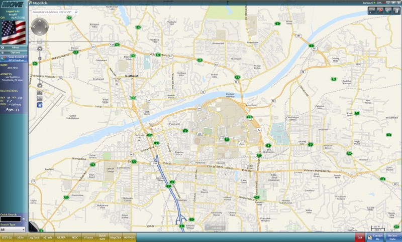
MapClick is a mapping application that is integrated into the MOVE framework. Location information from MapClick is stored in Move as objects that can be populated into eCite, eCrash or any of the applications residing in MOVE.
It has multiple layers for coordinates, node numbers, link numbers, road names, road codes and milepoints. With the layers tool, users can get details about layers, toggle between them, and turn them off.
Users can click a spot on the map and be provided with the two nearest nodes, the GPS coordinates,and an address. The user can populate this information into the various MOVE applications.
MapClick works independently, with an internet connection, or when paired with a GPS device:
independently: using location information stored within the program
internet connection: adds real-time location information from Google
GPS device: enables tracking, which shows the user’s car on the map and saves the current location
MapClick can be used as an alternative to Microsoft MapPoint. However, MapPoint remains integrated into MOVE.
Cite is an Electronic Citation Generation and Processing System.
It was developed as a process-level solution to the outdated and time-consuming paper citation form used by law enforcement and the court system. Citations generated through eCite are quick, accurate, secure, and legible.
eCite is more than a form. The vision for eCite was born out of the needs of the court system for timely and secure access to accurate citation data, but citation data was originated by law enforcement. Therefore, CAPS developed the eCite system as a means of collecting, cleaning, and analyzing data and making that data easily accessible by all agencies involved.
The eCite system is fully integrated into the Mobile Officers’ Virtual Environment (MOVE) and is not offered as a stand-alone product.
Process
eCite enables the entire citation process, from citation issuance to transferring citation data to the district court system, to be completed 100 percent electronically. NO hand-entered data!
The multiple users, interfaces, equipment, and state legislation involved this process solution illustrates CAPS’ integrated systems approach to software design and problem-solving.
eCite is utilized by officers in the field to issue tickets, print a copy for the violator, and transmit the data to a server repository using a laptop, notebook, or tablet PC.
eCite improves an officer’s safety and efficiency by enabling faster citation issuance, reducing exposure to a potentially dangerous defendant, and the ability to validate a defendant’s identity and view their previous records. Redundant paperwork is eliminated through an integrated activity logbook. These factors allow officers to spend a greater percentage of their shift in patrol and results in increased job satisfaction.
Law enforcement and court system personnel access officers submit data through CAPS developed administrative portals, eSwear, eSearch, and Advance.
The suite of administrative tools supports the electronic filing of citations with the court system, as well as the backend processing and archiving of the citation data.
eSwear is a virtual swearing process that allows the officer to swear to the authenticity of the ticket and the clerk to confirm via a touch-screen kiosk equipped with biometric-based authentication.
eSearch enables clerks and law enforcement administrators to search, access, and evaluate existing citations. Citations can be printed from this site as needed.
ADVANCE is a web portal dashboard enabling users to analyze and visualize data.
CAPS provides free, secure web services for law enforcement and court personnel to pull data collected in eCite into their records management systems (RMS) and court case management systems (CMS) respectively.
Overview Video
Features & MOVE Integration
Auto-populates citation data from driver’s license barcode and magnetic stripe scanning (MOVE integration)
Auto-populates driver’s license information (implemented by LETS-GO)
Auto-populates certain form fields with setting defaults (e.g., county, court, etc.)
Auto-populates driver and/or vehicle data from third-party applications (ASPEN*, etc.)
Auto-populates location data from GPS device
Interfaces with web pages and other applications through MOVE
Automated data validation (checks for consistency and completeness)
Citation replication (simplifies & speeds the writing of multiple offenses)
Defines screen templates for customized preset values
Automated, internet-based upload of ticket data to central data repository
Automated, internet-based download of ticket numbers from a central repository
Writes and tracks warning citations
Transfers data from eCite into officer’s daily activity log through MOVE
* ASPEN is a FMCSA software for federal electronic reporting of commercial vehicle violations Learn more about MOVE
Electronic Solution
Issuance: via the eCite software on laptops in the officer’s vehicles
eTransmittal: once Internet connectivity is established via cellular air cards or hot spots
eSwear: via a computer kiosk at the clerk’s office
eFiling: via the integrated network – no mailing of hard copies
ePayments: via credit card over the internet
eSearch and statistical analyses: via secure password-protected web portal
History, Sponsors, & Partners
eCite was initially developed with the support and guidance of the Alabama Administrative Office of Courts (AOC). Financial support was provided by the Federal Motor Carrier Safety Administration (FMCSA) and the Alabama Department of Economic and Community Affairs (ADECA). eCite was developed in cooperation with the Alabama Department of Public Safety (DPS) who provided invaluable feedback.
eCite was the first system within Alabama to utilize license scanners, GPS devices, and laptops to aid officers in the traffic citation writing process.
2002: eCite software development began
2003: Phase 1, eCite ticketing process pilot, executed at a fixed-base location truck weigh station in Heflin, Alabama.
2003: Phase 2, eCite mobile connectivity pilot, tested viability of cellular air cards for laptop Internet connectivity.
2003: Statewide eCite rollout to all motor carrier (MCSAP) state troopers.
2005: First municipal pilot was with the Tuscaloosa Police Department.
2007: 100% eCite adoption by Alabama state troopers. Alabama municipal rollout began.
2009: eCite pilot project in Roswell, New Mexico.
2010: eCite deployed for Mississippi Highway Patrol’s State Troopers.
2013: eCite deployed for Arkansas law enforcement personnel.
Today, eCite has been deployed in 300 municipalities and 4 states. Most Alabama state agencies use eCite and its user base continues to expand. Eighty percent of citations in Alabama are produced using eCite.
The eCite system is a client-based application, but it uses the Internet to transmit the tickets. If there is no connectivity, the tickets are stored to be transmitted later. This approach led to a successful pilot, which was followed shortly by a statewide rollout to all motor carrier (MCSAP) state troopers. The product was so popular and successful that the project has expanded to general vehicle enforcement troopers.
Customized for Other Jurisdicitons
Our developers can customize eCite for specific jurisdictions. eCite’s customization options, such as non-uniform traffic citations, commercial vehicle weight form for overweight citations, and record management systems integration, making it highly flexible for adaption to any jurisdiction, municipality, or state.
eCite’s successful Alabama deployment led to its customization and adoption by three other states: New Mexico, Mississippi, and Arkansas.
New Mexico
After eCite’s Alabama state-wide rollout in 2007, New Mexico became the second state to implement eCite. CAPS began a pilot eCite project in Roswell, NM, in 2009. The New Mexico Administrative Office of the Courts then contracted CAPS to develop a system that would aggregate electronic citation data from multiple vendors, including TraCS, and make the data available within the Court’s Case Management System (CMS).* This system of aggregating, cleaning, and integrating data eliminated repetitive data entry by the courts.
*New Mexico utilizes Odyssey Court Management System by Tyler Technologies which integrates with eCite.
Mississippi
Mississippi Highway Patrol (MHP) sponsored CAPS to customize and deploy eCite to all MHP Troopers and production use began in October 2010.
Tailoring eCite for Mississippi included:
Implementing a secure download of issued citations to the appropriate Justice Court jurisdictions
Providing administrative forms and procedures
Building a password-protected, administrative website for MHP supervisors
Developing a password-protected, analytical dashboard. The dashboard has drill-down capabilities for all data element(s) contained in eCite and GPS mapping based on citation issuance.
After the successful deployment of eCite with only the basic traffic citation, MHP commissioned CAPS to add DUI citations. Now all citations, including DUI, are transferred to the courts electronically.
Currently, there are approximately 600 officers using the system. MHP has begun deploying eCite to local agencies. In Mississippi, there have been over 1.6 million citations issued with the eCite system and over 93 percent of all citations have been transferred to the courts electronically.
Arkansas
Arkansas State Police (ASP) contracted CAPS to develop a customized eCite solution for all Arkansas law enforcement personnel and the deployment process began in early 2013.
Tailoring eCite for Arkansas included:
Customizing forms for citations and administrative products
Connecting to the Arkansas State NCIC Switch in real-time for onboard data retrieval
Developing Arkansas Threat Level Assessment System (ATLAS)
Atlas is a UI Rich NCIC application that allows officers to conduct NLETS searches through the state’s message switch and to auto-populate eCite with the resulting data. ATLAS is used by all ASP Highway Patrol and over 10 million queries have been performed using the application.
eCite is used by Arkansas State Police’s entire highway patrol unit and ASP is working with local agencies to deploy eCite to all municipalities. Since its implementation in 2013, 1.8 million eCite documents have been submitted.
Implementation Benefits
eCite revolutionized the citation process for Alabama law enforcement and court system personnel by improving accuracy, efficiency, and safety. While eCite fulfilled all its project goals, it’s highway safety benefits and research implications are deeply rooted in CAPS’ mission for its software research and development to make the world a safer and better place.
Law Enforcement Personnel
Reduced exposure to potentially dangerous defendants due to faster citation issuance
Increased situational awareness via GPS and LETS integration (LETS provides individual, vehicle, and violation data to law enforcement and criminal justice agencies.)
Reduced amount of redundant paperwork due to integrated activity logbook
Increased job satisfaction due to less citation generation effort
Court System Personnel
Increased citation legibility due to electronic data entry
Improved access due to immediate addition of citation to electronic database/court jurisdictions
Increased citation completion due to essential form field checks
Increased accuracy due to in-field consistency checks
Increased revenue due to the speedy issuance of single or multiple citations
Increased efficiency of court clerks due to elimination of data re-entry processes
Elimination of backlogged tickets
Highway Safety
Thorough enforcement due to streamlined citation process and informative citation analytics
Increased officer patrol time due to efficient citation process
Increased meaning for warning tickets due to reviewability in database
Identification of serial citation recipients due to immediate availability of electronic citations
Research
Optimized enforcement efforts due to citation data analytics
Access to defendant demographic data (e.g., background information, types of citations issued, etc.)
Access to citation location data due to GPS integration
I Want eCite
Alabama Agencies
eCite is free of charge to Alabama law enforcement agencies.
New users must complete initial forms that include providing the municipal court information and municipal adopting codes. This information is necessary to customize the software before you can begin using it. User accounts will be set up for agency officers.
Training manuals are available upon request: email care@cs.ua.edu
Inquiries
eCite can be adapted for any state or municipality. If you are interested in implementing eCite, another CAPS product, or working with CAPS on a custom solution, we want to hear from you!
This study was conducted at the request of an advocate group that wanted information to assist them in developing public information and education countermeasuers for teen-age drivers. While most past CAPS studies of youth-involved drivers were limited to 16-20 year olds, the advocate group was also interested in 15 year olds, and they were not interested in 20 year olds since their projects were oriented around teen drivers. Several studies were conducted, including CARE IMPACT studies that compared 15, 16-19 and 15-19 year old causal drivers with causal drivers in the older age group.